Monday, April 24, 2006
CHASE: 4/24/06
Elevated convection fired overnight in NC OK and left an E-W oriented outflow boundary in its wake. We were hoping that the air to the north of the boundary would destabilize in order that we could have a storm ingest the higher vorticity air assoicated with the boundary. This wasn't to be; several rounds of convection fired later in the afternoon and drew some chasers further to the northeast. We decided to stick around Kingfisher for the majority of the afternoon, in hopes of better convection closer to the instability axis (CAPEs had risen to 4000 j/kg). Even so, we were concerned about the relative lack of shear further south, so we only reluctantly headed southward from Kingfisher when it became apparent that the northern target wasn't going to work out. Our hesitance turned out to be a blessing in disguise, as our original target storm near Anadarko became more and more linear on radar as we approached. However, a new storm developed explosively southwest of El Reno. Within a few short volume scans, it was apparent that the storm had became a full-blown supercell with rotation evident on SRV Tilt 2.
When we first saw the base of this storm, it was rather flat with a distinct lack of scud. However, it was very isolated (especially when compared with storms further south), so we were optimistic about its potential. Around 7 p.m., the storm really began to take off. The structure was amazing: beaver tail, vault, powerful updraft, and a wall cloud were all visible from our location. Shortly after this, rotation became evident in the wall cloud. From here, a classic tornadogenesis sequence began with increasing wall cloud rotation (associated with an advancing RFD), increasing tail cloud motion from the north, and intermittent funnel clouds as the low-level meso began to occlude.
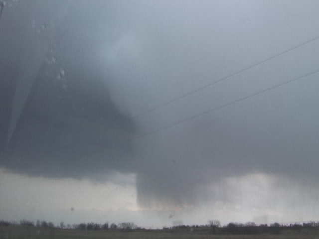
At 7:26 p.m., a tornado finally set down about 5 or 6 miles WSW of El Reno. The tornado started as a slender rope, but quickly grew into a very photogenic stovepipe tornado. The tornado displayed tremendous vertical velocities along the edges of the funnel (which was quite laminar). Meanwhile, another funnel began to develop along the anticyclonic member of the rotational pair about 5 miles to the south of the original tornado. This funnel became a rather spectacular tornado in its own right within about halfway through the lifespan of the first tornado. This marks the first time I've ever seen double tornadoes (not satellite tornadoes); I really had a tough time figuring out which tornado I wanted to shoot! LOL. At any rate, both tornadoes roped out rather elegantly (the first was particularly spectacular---it changed shape rather rapidly). After this, we followed the storm in hopes that more tornadoes would form (I was sure that it wasn't over), but none did. I supsect that convection to the southeast of the El Reno storm contaminated its inflow.
This was an absolutely fabulous chase! I still can't believe it all happened within an hour's drive of my house. Can't beat that.
 Tornado touches down WSW of El Reno (~7:25 p.m.)
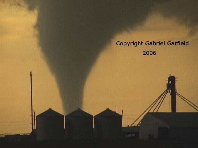 Tornado transitions to stovepipe shape as it intensifies.
 Tornado begins to weaken.
 Tornado ropes out.
 New tornado forms to the southwest as old tornado ropes out.
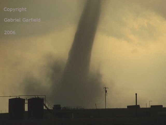
Zoom shot of anticyclonic tornado.
Thursday, April 06, 2006
FCST: 4/6/06
Today's date is April 6th, 2006. Five years ago today, I chased my first high risk in western Oklahoma. Really, the only thing similar between that day and this day is that the highest SPC categorical risk is the same. That day featured a very thick cirrus canopy that inhibited daytime heating for the vast majority of the day. That will not be the case today, as a very pronounced mid-level dryslot rotates around the base of the upper trough. Even looking at this trough on satellite, it looks like a doozy. Classic comma head appearance---it just looks like it wants to eat something!
The days leading up to now were filled with much uncertainty about whether or not today would be a big day. Most of the storm chasing community knew there was some potential for today, if things shaped up nicely. However, doubts about the position of the dryline, the quality of moisture return, and storm motion prevented us Oklahoma chasers from getting too excited. But, last night, the models began their westward trend and our optimism began to grow.
The next item on the forecast list is the potential for an outflow boundary. As I write this, elevated showers and thunderstorms are rapidly sweeping across Oklahoma from border to border. The showers are favorably timed (i.e. they shouldn’t negatively impact daytime heating), so the outflow boundary should have plenty of time to cook under the early April sun. Of course, the impact is three-fold (as usual). First, it will enhance vorticity (because of its inherent baroclinicity) via density differences across the boundary (i.e. warm air rises, cold air sinks). This will create a horizontal circulation that can then be tilted and stretched into the vertical (where you need spin when you want a tornado). Second, it will lower LCL heights (on the north side of the boundary), which has been shown to be very favorable for the development of tornadoes. Third, it will create a focus for convergence and storm development (parameters are great, but you still need a storm!). So, all in all, this is a very positive development in our quest for the ever-elusive tornado.
Because of these favorable developments, I expect the high risk will be expanded to include NE OK into SW MO. Personally, I feel that (other than storm motions) the most favorable region for the development of strong, long-lived tornadoes is in far SE KS, NE OK, and into SW MO. Here, storms will remain more isolated and will have access to high-octane moisture. The only negative here (as compared to further north) is that pressure falls will not be as significant. However, this should not preclude the development of very dangerous tornadic supercells.
Target: Bartlesville, OKEDIT: The newest RUC looks *awesome*. If this were to verify, I'd expect an outbreak of tornadoes. However, the RUC still seems to be a bit bullish on Tds (compared to the observations). I love how storm fire in SC KS by 21Z! Further west is much, MUCH better. In addition, it seems that all the vort is compacted into one lobe, which is progged to be perfectly timed with daytime heating. Also, sfc winds are still sig. backed, which is maximizing 0-1 km helicity and keeping storm motions down a tad. I love it! Now, if it'll just verify...
Tuesday, April 04, 2006
FCST: 4/1/06
CHASE: 3/30/06
This day was fairly hyped up by the forecasting outlets (SPC, WFOs, etc.) for the potential of a significant severe weather event. The SPC issued a moderate risk in the first outlook of the day, and maintained that category (instead of raising to high) based on moisture and instability issues (as is typical of early season chase days). Even still, SPC mentioned the possibility of isolated strong tornadoes from Nebraska down to eastern Oklahoma. After taking one look at the forecasted low-level shear (>200 m2/s2 of 0-1 km helicity), I had to agree.
Justin Walker, Brandon Lawson, Jana Lesak, and Jeff Snyder met outside my house at about 12:20, and storms had already fired in western Oklahoma on the dryline (which proved to be problematic since full insolation was never established in E OK). The good news was that these storms were already showing signs of “discretizing,” as they had formed quickly into a line initially. We headed south on I-35 and west on Highway 9 to get in position for a supercell that was approaching Blanchard. We headed as far south as Dibble where we gassed up the vehicles. We went a bit too far south relative to the storm’s track, so we had to head up to “storm chaser hill” just SW of Blanchard (this is old Hw. 62). This afforded us a spectacular view of the storm that by this time was a massive high precipitation supercell. The structure was fantastic, but it was obvious that this storm was not going to do it, as far as tornadoes were concerned. With al little deliberation, we decided to head south to another supercell near Duncan.
On our way southward, we saw our second supercell of the day near Lindsay, Oklahoma. This storm was far more classic than the last (actually, almost looked LP). Still, we ignored this storm in favor of the more developed southern storms.
Somewhere near Purdy (if memory serves), we saw yet another supercell. This storm was a little bit more strung out, and it had a lot of “flanking line garbage.” Because there was still another supercell to its south, we ditched this storm to chase the next one in line. This one had 70+ dBz refelectivity and a well-developed hook echo.
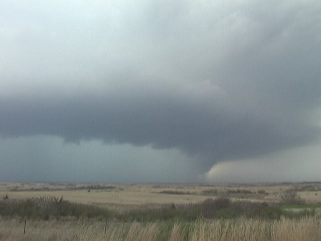
Finally, we arrived at the southernmost supercell, and boy, was it a doozy. The mesocyclone was much larger than the past three, and definitely more vertical. In addition, the rotation was very strong in the midlevels. Somewhere near Pernell, we saw a very well developed low-level mesocyclone. It was rotating very quickly, and it seemed that a tornado was inevitable. Indeed, we received a report (via HAM radio) that this storm was in the process of producing a tornado. However, I believe this tornado must have been in the rain, because we could not make a visual. At any rate, this storm continued toward Pauls Valley, where it became very disorganized. We chased the storm for another 30 minutes or so east of I-35, when we finally decided to ditch this supercell for another developing supercell that had formed along the outflow of the old Pernell supercell.
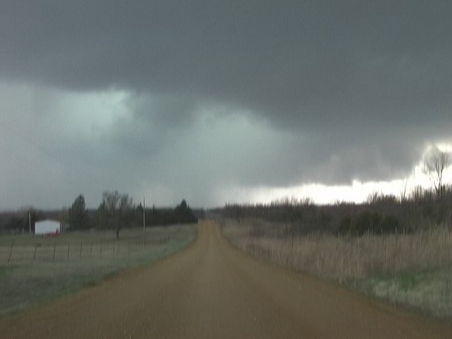
We intercepted this new supercell near the town of Ada. This supercell exhibited mostly high precipitation storm character, but was, for a short while, on the wet side of classic. The low-level mesocyclone of this particular storm was absolutely tremendous. Rain curtains could be seen rotating rapidly to our southwest. I thought for sure this storm was hiding a tornado. Well, we will never know, for another surge of precipitation ripped through the l.l. meso and completely obscured it from view. Nearer the town of Ada, the storm became fully HP. We watched as the outer rain curtains approached our location. The rain/no rain gradient was very tight! It was really cool to see the rain fall heavily at locations just over ½ mile away while no rain was falling on our location! We then made a hasty retreat to the north, but due to a wrong road decision (I was on the phone with my Dad who was giving me important news) on my part, we ended up getting cored! Hail as big as ping-pongs fell from the sky all around us. Thank goodness they weren’t any bigger! At any rate, we had to navigate the backroads of SE OK, which is no small task! Finally, we got in position again just to the north of the l.l. meso (in the bear’s cage), where we saw an extremely low wall cloud. It had the shape of a wannabe wedge, but the rotation was just not significant enough to produce a tornado. We chased this supercell for another couple hours toward McAlester, but none of what we saw thereafter was that significant.
This chase was fairly good, as far as chases are concerned, but it still lacked the one thing that can make any chase great: a tornado. Call me jaded, but I was a little disappointed. Nevertheless, it was a fun chase, and I'm still amazed that I was chasing storms for 7 hours straight! During that time, we saw 5 different supercells. Not too shabby!
Blanchard, OK supercell

Velma/Pernell Supercell
Ada supercell
Well-defined hail shaft
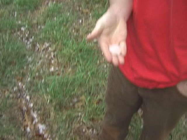
Brandon Lawson holds quarter to half-dollar sized hail.
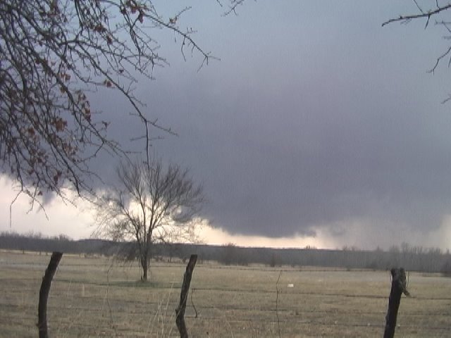
Very low wall cloud near Gerty, OK.
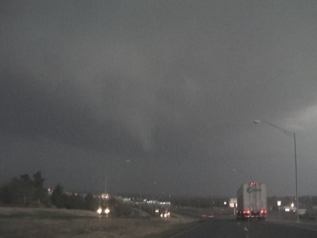
Brief funnel cloud NE of McAlester
![]()