Monday, April 24, 2006
CHASE: 4/24/06
I wasn't too excited about the prospects for chasing on Monday until I perused the 24 April 00Z Eta run. I was shocked to see how a pretty marginal setup had evolved into a classic setup for chaseable tornadic supercells. The Eta forecasted that >3000 j/kg of MLCAPE would coincide with backed surface winds (SE to ESE) in northern Oklahoma into southern Kansas. Because of the forecasted strong veering in the lowest 3 kilometers of the troposphere, the Eta model developed a fairly broad region of enhanced low-level shear E and NE of the triple point. When I saw the forecast soundings, my mouth dropped. The CAPE/shear profile was almost ideal for significant tornadic supercells. The hodographs had the classic kink at about 2 kilometers that has been shown to be associated with many significant tornado events (given sufficient instability). Unfortunately, this relatively simple forecast became quite complicated on Monday morning.
Elevated convection fired overnight in NC OK and left an E-W oriented outflow boundary in its wake. We were hoping that the air to the north of the boundary would destabilize in order that we could have a storm ingest the higher vorticity air assoicated with the boundary. This wasn't to be; several rounds of convection fired later in the afternoon and drew some chasers further to the northeast. We decided to stick around Kingfisher for the majority of the afternoon, in hopes of better convection closer to the instability axis (CAPEs had risen to 4000 j/kg). Even so, we were concerned about the relative lack of shear further south, so we only reluctantly headed southward from Kingfisher when it became apparent that the northern target wasn't going to work out. Our hesitance turned out to be a blessing in disguise, as our original target storm near Anadarko became more and more linear on radar as we approached. However, a new storm developed explosively southwest of El Reno. Within a few short volume scans, it was apparent that the storm had became a full-blown supercell with rotation evident on SRV Tilt 2.
When we first saw the base of this storm, it was rather flat with a distinct lack of scud. However, it was very isolated (especially when compared with storms further south), so we were optimistic about its potential. Around 7 p.m., the storm really began to take off. The structure was amazing: beaver tail, vault, powerful updraft, and a wall cloud were all visible from our location. Shortly after this, rotation became evident in the wall cloud. From here, a classic tornadogenesis sequence began with increasing wall cloud rotation (associated with an advancing RFD), increasing tail cloud motion from the north, and intermittent funnel clouds as the low-level meso began to occlude.
At 7:26 p.m., a tornado finally set down about 5 or 6 miles WSW of El Reno. The tornado started as a slender rope, but quickly grew into a very photogenic stovepipe tornado. The tornado displayed tremendous vertical velocities along the edges of the funnel (which was quite laminar). Meanwhile, another funnel began to develop along the anticyclonic member of the rotational pair about 5 miles to the south of the original tornado. This funnel became a rather spectacular tornado in its own right within about halfway through the lifespan of the first tornado. This marks the first time I've ever seen double tornadoes (not satellite tornadoes); I really had a tough time figuring out which tornado I wanted to shoot! LOL. At any rate, both tornadoes roped out rather elegantly (the first was particularly spectacular---it changed shape rather rapidly). After this, we followed the storm in hopes that more tornadoes would form (I was sure that it wasn't over), but none did. I supsect that convection to the southeast of the El Reno storm contaminated its inflow.
This was an absolutely fabulous chase! I still can't believe it all happened within an hour's drive of my house. Can't beat that.
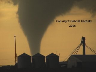
 Tornado touches down WSW of El Reno (~7:25 p.m.)
 Tornado transitions to stovepipe shape as it intensifies.
 Tornado begins to weaken.
 Tornado ropes out.
 New tornado forms to the southwest as old tornado ropes out.

Zoom shot of anticyclonic tornado.
Elevated convection fired overnight in NC OK and left an E-W oriented outflow boundary in its wake. We were hoping that the air to the north of the boundary would destabilize in order that we could have a storm ingest the higher vorticity air assoicated with the boundary. This wasn't to be; several rounds of convection fired later in the afternoon and drew some chasers further to the northeast. We decided to stick around Kingfisher for the majority of the afternoon, in hopes of better convection closer to the instability axis (CAPEs had risen to 4000 j/kg). Even so, we were concerned about the relative lack of shear further south, so we only reluctantly headed southward from Kingfisher when it became apparent that the northern target wasn't going to work out. Our hesitance turned out to be a blessing in disguise, as our original target storm near Anadarko became more and more linear on radar as we approached. However, a new storm developed explosively southwest of El Reno. Within a few short volume scans, it was apparent that the storm had became a full-blown supercell with rotation evident on SRV Tilt 2.
When we first saw the base of this storm, it was rather flat with a distinct lack of scud. However, it was very isolated (especially when compared with storms further south), so we were optimistic about its potential. Around 7 p.m., the storm really began to take off. The structure was amazing: beaver tail, vault, powerful updraft, and a wall cloud were all visible from our location. Shortly after this, rotation became evident in the wall cloud. From here, a classic tornadogenesis sequence began with increasing wall cloud rotation (associated with an advancing RFD), increasing tail cloud motion from the north, and intermittent funnel clouds as the low-level meso began to occlude.
At 7:26 p.m., a tornado finally set down about 5 or 6 miles WSW of El Reno. The tornado started as a slender rope, but quickly grew into a very photogenic stovepipe tornado. The tornado displayed tremendous vertical velocities along the edges of the funnel (which was quite laminar). Meanwhile, another funnel began to develop along the anticyclonic member of the rotational pair about 5 miles to the south of the original tornado. This funnel became a rather spectacular tornado in its own right within about halfway through the lifespan of the first tornado. This marks the first time I've ever seen double tornadoes (not satellite tornadoes); I really had a tough time figuring out which tornado I wanted to shoot! LOL. At any rate, both tornadoes roped out rather elegantly (the first was particularly spectacular---it changed shape rather rapidly). After this, we followed the storm in hopes that more tornadoes would form (I was sure that it wasn't over), but none did. I supsect that convection to the southeast of the El Reno storm contaminated its inflow.
This was an absolutely fabulous chase! I still can't believe it all happened within an hour's drive of my house. Can't beat that.
 Tornado touches down WSW of El Reno (~7:25 p.m.)
 Tornado transitions to stovepipe shape as it intensifies.
 Tornado begins to weaken.
 Tornado ropes out.
 New tornado forms to the southwest as old tornado ropes out.
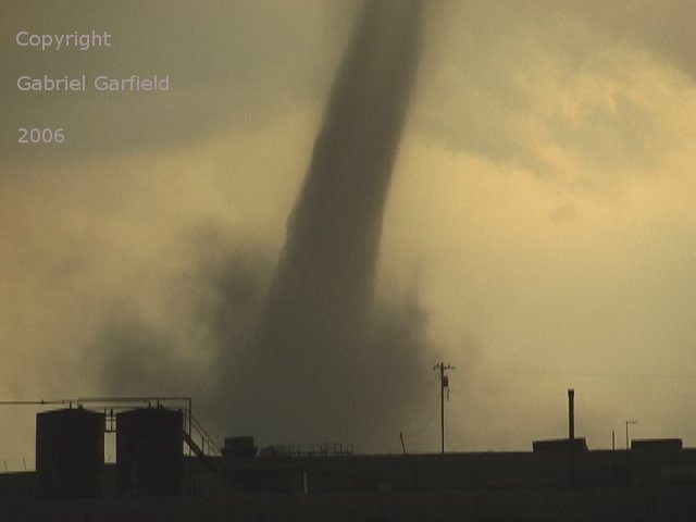
Zoom shot of anticyclonic tornado.
# posted by Gabe Garfield @ 10:22 PM 
Comments:
<< Home
I figure if we leave by 3am, we can make it to Minot ND by initiation. Oh wait, the upcoming pattern change only RESEMBLES July. Apparently, the atmosphere only thinks it can look like March or July, with limited moisture or weak flow aloft, marginal CAPE or the main belt of the westerlies along the USA/Canada border. {Rolls eyes}

I'm working on it, bro! Well, not really...I will be working on it though! :-P
Ok, I'm inspired. Loook for new chase sums soon.
Post a Comment
Ok, I'm inspired. Loook for new chase sums soon.
<< Home
![]()