Friday, March 31, 2006
BUST: 3/29/06
We knew this day would be very conditional (because of the cap), but the severe parameters were too tasty to resist. Large-scale forcing was weak (vorticity maximum was still quit far to the west), so we were hoping that the dryline circulation would be sufficient initiate convection. CAPE was forecast to be moderate (around 1500 j/kg) and low-level shear was progged to be quite intense (>300 m2/s2 of 0-1 km SRH). In addition, we hoped that an outflow boundary would intersect with the dryline and provide an additional source of convergence (and resulting lift). Based on this, we targeted Hollis, Oklahoma.
We (Jeff Snyder, Kim, Brandon Lawson, Grant Hicks, Bethany Vanderpool, and I) left Norman around 12 p.m. for SW Oklahoma. We took the usual route down to Lawton (via HW 62 and I-44) and then west on HW 62 toward Altus. We arrived in our target around 3 p.m. and obtained a WiFi connection in Altus. After perusing data for a while, it was becoming increasingly apparent that the cap would not break. Even still, we headed west to obtain a visual of the dryline. There were a few elevated towers just west of the Oklahoma/Texas border, but it was obvious we were busted. Thus, around 6 p.m., we headed back home. We stopped in Lawton for a meal, and made it back into Norman by 10.
Chase-wise, this was a very poor chase. Yet, it was nice to get out again with friends and enjoy the scenes of southwestern Oklahoma.
Wednesday, March 29, 2006
FORECAST: 3/29/06
In addition, the exiting convection should leave an outflow boundary in its wake, which the Eta has hinted at for a few days now. This boundary will most likely intersect the dryline in SW OK. As usual with OFBs, it will enhance low-level vorticity, keep LCLs relatively low (along and north of it), and provide a focus for convergence. Should significant insolation begin this morning, I think I will probably venture out to western Oklahoma this afternoon.
Target: Hollis, OK
ETD: 12 p.m.
Wednesday, March 22, 2006
CHASE: 3/20/06
The day started out with an email from Justin Walker in which he indicated that there was a real possibility of “mini-supercells” associated with a cold core system (temps around –25 C). The setup was certainly classic; a warm front was occluding near the surface low along and just north of I-40, a dryline extended to the SSW from the surface low, and dewpoint depressions were around 5 degrees F or less to the north of the front. More importantly, strong insolation was taking place across all of western Oklahoma that definitely increased the low-level lapse rates and associated low-level instability.Originally, we (Justin, Jeff Snyder, and I) were thinking of heading SW to Chickasha where the RUC model indicated the warm front would setup. However, the front lifted quite a bit further north to just past the I-40 corridor (which was quite fortunate considering the 850/500 mb crossover was a bit more favorable for cyclonic storm rotation). At about 11:30 am, we headed west on I-40 toward our new target area. We ate lunch in Weatherford, and were informed by Dan Dawson that the SPC had removed the 2% tornado probs and that there was essentially no risk at all for tornadoes. Thank the Lord the “experts” don’t determine how the weather will turn out (though, I wish they were a little more accurate on those big hype days)!
Convection began to fire around 2 pm, and we decided to head west toward Clinton and then north on Highway 183 to get closer to the surface boundary. An isolated storm formed NW of Clinton in Custer county and quickly exhibited high radar reflectivities (on the order of 55 dBz). As we neared Taloga, the lower cloud bases associated with the cooler air to the north of the boundary became very apparent just to our north. We decided to setup at a location ~8 miles ESE of Taloga to watch the storm approach from the SW. We hoped that the storm would acquire rotation and then drop a tornado as it crossed the boundary.
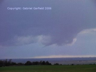
At around 4:15 pm, the base of the storm began to lower to our SW. Fifteen minutes later, an RFD became evident (by the erosion of the wall cloud due to subsidence).

Finally, a horizontal funnel developed.
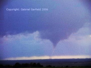
The funnel was thin tilted and stretched, and tornadogenesis occurred. (Image enhanced for contrast.)
Another view of the tornado (also image enhanced.)

The funnel was intermittently in contact with the ground for the next two minutes or so. After this, we headed south toward a new circulation that had formed east of the original. However, significant convection formed to the southeast of the storm which cooled the inflow parcels to our storm and reduced instability. We tinkered around with some other storms to the east, but it was obvious that none of them had a shot at producing a tornado.
Monday, March 20, 2006
FORECAST: 3/20/06
Also, Jon Davies NSTP composite index is maximized by the RUC from SW OK at 21Z to C OK at 00Z. With insolation likely beginning in earnest shortly, low-level lapse rates will also be maximized which will yield a very favorable environment for the tilting and stretching of the low-level vorticity (which should be in abundance today).
Targeting the interesection of the warm front with the low center, which should be NW of Lawton by 21Z. Hype is low, hope is high. :-D
Thursday, March 09, 2006
Bustorama, Version 2.0: 3/8/06
My chase group and I (which consisted of Mark Oerther, Justin Walker, Grant Hicks, Jeff Snyder, Jeff's fiance, Bryan Saliseder, Brandon Lawson, and myself) set out for an initial target of Ardmore, Oklahoma. At the Microtel hotel, we established a WiFi connection and waited for the first storms to fire. We saw Shane Adams and Mickey Ptak again, along with Aaron Kennedy and crew. It was quite the chaser convergence! At any rate, storms did fire to our southwest, but they exhibited anticylonic rotation in the middle levels of the atmosphere (according to the SRV data)! Apparently, the winds above 700 mb were backing somewhat with height, which gave a favorable hodograph (at least, for those levels) for clockwise storm rotation. As the evening wore on, it became painfully obvious that the vort max would not arrive in time for surface based development to occur. We headed home at around 6:45 (a bit later than we expected, due to incredibly slow service at the local McDonald's), and were treated to a nice lightning show to the south and east.
Overall, I give this chase a 3 out of 10, because though we never had surface based storms, we at least had lightning this time around. Also, good company makes for an easier bust.
Tuesday, March 07, 2006
Bustorama: 3/7/06
Based on this information, Justin Walker and I targeted SC KS (specifically, Wellington) because it appeared that this area would have the extra advantage of lower LCL heights. We left Norman around 11:30 and made it to the Wellington area shortly after 2 pm. On the way up, we noticed that the cirrus deck that had been in place during the morning over NW OK into SC KS was beginning to erode somewhat. The sun peeked through a little bit around the Perry area, but it was becoming obvious (based on ThreatNet satellite) that the cloud deck would not erode quickly enough. We ended up spending a good 2 hours waiting around in Wellington before we decided to call it a day. On the way home, we spotted a few "blips" on ThreatNet that kept it interesting, but ultimately, a bust is a bust. We ended up seeing Mickey Ptak and Shane Adams in Blackwell, which made the day rather nice (I love talking to Shane about old storm days--he knows as much as I do about the classic chases).
All in all, I'll give this chase a 2 out of 10. Not absolutely pathetic, but almost. Here's hoping for tomorrow!

