Wednesday, March 22, 2006
CHASE: 3/20/06
The day started out with an email from Justin Walker in which he indicated that there was a real possibility of “mini-supercells” associated with a cold core system (temps around –25 C). The setup was certainly classic; a warm front was occluding near the surface low along and just north of I-40, a dryline extended to the SSW from the surface low, and dewpoint depressions were around 5 degrees F or less to the north of the front. More importantly, strong insolation was taking place across all of western Oklahoma that definitely increased the low-level lapse rates and associated low-level instability.Originally, we (Justin, Jeff Snyder, and I) were thinking of heading SW to Chickasha where the RUC model indicated the warm front would setup. However, the front lifted quite a bit further north to just past the I-40 corridor (which was quite fortunate considering the 850/500 mb crossover was a bit more favorable for cyclonic storm rotation). At about 11:30 am, we headed west on I-40 toward our new target area. We ate lunch in Weatherford, and were informed by Dan Dawson that the SPC had removed the 2% tornado probs and that there was essentially no risk at all for tornadoes. Thank the Lord the “experts” don’t determine how the weather will turn out (though, I wish they were a little more accurate on those big hype days)!
Convection began to fire around 2 pm, and we decided to head west toward Clinton and then north on Highway 183 to get closer to the surface boundary. An isolated storm formed NW of Clinton in Custer county and quickly exhibited high radar reflectivities (on the order of 55 dBz). As we neared Taloga, the lower cloud bases associated with the cooler air to the north of the boundary became very apparent just to our north. We decided to setup at a location ~8 miles ESE of Taloga to watch the storm approach from the SW. We hoped that the storm would acquire rotation and then drop a tornado as it crossed the boundary.
At around 4:15 pm, the base of the storm began to lower to our SW. Fifteen minutes later, an RFD became evident (by the erosion of the wall cloud due to subsidence).

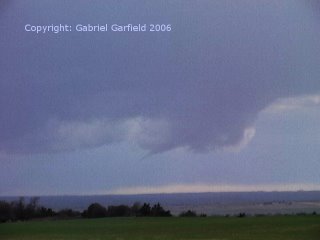
Finally, a horizontal funnel developed.
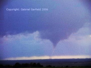
The funnel was thin tilted and stretched, and tornadogenesis occurred. (Image enhanced for contrast.)
Another view of the tornado (also image enhanced.)

The funnel was intermittently in contact with the ground for the next two minutes or so. After this, we headed south toward a new circulation that had formed east of the original. However, significant convection formed to the southeast of the storm which cooled the inflow parcels to our storm and reduced instability. We tinkered around with some other storms to the east, but it was obvious that none of them had a shot at producing a tornado.


