Tuesday, April 04, 2006
CHASE: 3/30/06
I’m a little late in writing this particular summary, but it was a pretty good chase so I’d better get to it before my memory fades!
This day was fairly hyped up by the forecasting outlets (SPC, WFOs, etc.) for the potential of a significant severe weather event. The SPC issued a moderate risk in the first outlook of the day, and maintained that category (instead of raising to high) based on moisture and instability issues (as is typical of early season chase days). Even still, SPC mentioned the possibility of isolated strong tornadoes from Nebraska down to eastern Oklahoma. After taking one look at the forecasted low-level shear (>200 m2/s2 of 0-1 km helicity), I had to agree.
Justin Walker, Brandon Lawson, Jana Lesak, and Jeff Snyder met outside my house at about 12:20, and storms had already fired in western Oklahoma on the dryline (which proved to be problematic since full insolation was never established in E OK). The good news was that these storms were already showing signs of “discretizing,” as they had formed quickly into a line initially. We headed south on I-35 and west on Highway 9 to get in position for a supercell that was approaching Blanchard. We headed as far south as Dibble where we gassed up the vehicles. We went a bit too far south relative to the storm’s track, so we had to head up to “storm chaser hill” just SW of Blanchard (this is old Hw. 62). This afforded us a spectacular view of the storm that by this time was a massive high precipitation supercell. The structure was fantastic, but it was obvious that this storm was not going to do it, as far as tornadoes were concerned. With al little deliberation, we decided to head south to another supercell near Duncan.
On our way southward, we saw our second supercell of the day near Lindsay, Oklahoma. This storm was far more classic than the last (actually, almost looked LP). Still, we ignored this storm in favor of the more developed southern storms.
Somewhere near Purdy (if memory serves), we saw yet another supercell. This storm was a little bit more strung out, and it had a lot of “flanking line garbage.” Because there was still another supercell to its south, we ditched this storm to chase the next one in line. This one had 70+ dBz refelectivity and a well-developed hook echo.
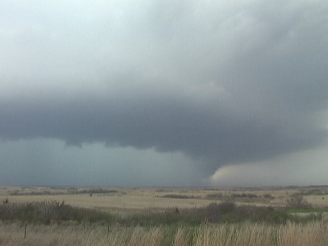
Finally, we arrived at the southernmost supercell, and boy, was it a doozy. The mesocyclone was much larger than the past three, and definitely more vertical. In addition, the rotation was very strong in the midlevels. Somewhere near Pernell, we saw a very well developed low-level mesocyclone. It was rotating very quickly, and it seemed that a tornado was inevitable. Indeed, we received a report (via HAM radio) that this storm was in the process of producing a tornado. However, I believe this tornado must have been in the rain, because we could not make a visual. At any rate, this storm continued toward Pauls Valley, where it became very disorganized. We chased the storm for another 30 minutes or so east of I-35, when we finally decided to ditch this supercell for another developing supercell that had formed along the outflow of the old Pernell supercell.
We intercepted this new supercell near the town of Ada. This supercell exhibited mostly high precipitation storm character, but was, for a short while, on the wet side of classic. The low-level mesocyclone of this particular storm was absolutely tremendous. Rain curtains could be seen rotating rapidly to our southwest. I thought for sure this storm was hiding a tornado. Well, we will never know, for another surge of precipitation ripped through the l.l. meso and completely obscured it from view. Nearer the town of Ada, the storm became fully HP. We watched as the outer rain curtains approached our location. The rain/no rain gradient was very tight! It was really cool to see the rain fall heavily at locations just over ½ mile away while no rain was falling on our location! We then made a hasty retreat to the north, but due to a wrong road decision (I was on the phone with my Dad who was giving me important news) on my part, we ended up getting cored! Hail as big as ping-pongs fell from the sky all around us. Thank goodness they weren’t any bigger! At any rate, we had to navigate the backroads of SE OK, which is no small task! Finally, we got in position again just to the north of the l.l. meso (in the bear’s cage), where we saw an extremely low wall cloud. It had the shape of a wannabe wedge, but the rotation was just not significant enough to produce a tornado. We chased this supercell for another couple hours toward McAlester, but none of what we saw thereafter was that significant.
This chase was fairly good, as far as chases are concerned, but it still lacked the one thing that can make any chase great: a tornado. Call me jaded, but I was a little disappointed. Nevertheless, it was a fun chase, and I'm still amazed that I was chasing storms for 7 hours straight! During that time, we saw 5 different supercells. Not too shabby!
This day was fairly hyped up by the forecasting outlets (SPC, WFOs, etc.) for the potential of a significant severe weather event. The SPC issued a moderate risk in the first outlook of the day, and maintained that category (instead of raising to high) based on moisture and instability issues (as is typical of early season chase days). Even still, SPC mentioned the possibility of isolated strong tornadoes from Nebraska down to eastern Oklahoma. After taking one look at the forecasted low-level shear (>200 m2/s2 of 0-1 km helicity), I had to agree.
Justin Walker, Brandon Lawson, Jana Lesak, and Jeff Snyder met outside my house at about 12:20, and storms had already fired in western Oklahoma on the dryline (which proved to be problematic since full insolation was never established in E OK). The good news was that these storms were already showing signs of “discretizing,” as they had formed quickly into a line initially. We headed south on I-35 and west on Highway 9 to get in position for a supercell that was approaching Blanchard. We headed as far south as Dibble where we gassed up the vehicles. We went a bit too far south relative to the storm’s track, so we had to head up to “storm chaser hill” just SW of Blanchard (this is old Hw. 62). This afforded us a spectacular view of the storm that by this time was a massive high precipitation supercell. The structure was fantastic, but it was obvious that this storm was not going to do it, as far as tornadoes were concerned. With al little deliberation, we decided to head south to another supercell near Duncan.
On our way southward, we saw our second supercell of the day near Lindsay, Oklahoma. This storm was far more classic than the last (actually, almost looked LP). Still, we ignored this storm in favor of the more developed southern storms.
Somewhere near Purdy (if memory serves), we saw yet another supercell. This storm was a little bit more strung out, and it had a lot of “flanking line garbage.” Because there was still another supercell to its south, we ditched this storm to chase the next one in line. This one had 70+ dBz refelectivity and a well-developed hook echo.
Finally, we arrived at the southernmost supercell, and boy, was it a doozy. The mesocyclone was much larger than the past three, and definitely more vertical. In addition, the rotation was very strong in the midlevels. Somewhere near Pernell, we saw a very well developed low-level mesocyclone. It was rotating very quickly, and it seemed that a tornado was inevitable. Indeed, we received a report (via HAM radio) that this storm was in the process of producing a tornado. However, I believe this tornado must have been in the rain, because we could not make a visual. At any rate, this storm continued toward Pauls Valley, where it became very disorganized. We chased the storm for another 30 minutes or so east of I-35, when we finally decided to ditch this supercell for another developing supercell that had formed along the outflow of the old Pernell supercell.
We intercepted this new supercell near the town of Ada. This supercell exhibited mostly high precipitation storm character, but was, for a short while, on the wet side of classic. The low-level mesocyclone of this particular storm was absolutely tremendous. Rain curtains could be seen rotating rapidly to our southwest. I thought for sure this storm was hiding a tornado. Well, we will never know, for another surge of precipitation ripped through the l.l. meso and completely obscured it from view. Nearer the town of Ada, the storm became fully HP. We watched as the outer rain curtains approached our location. The rain/no rain gradient was very tight! It was really cool to see the rain fall heavily at locations just over ½ mile away while no rain was falling on our location! We then made a hasty retreat to the north, but due to a wrong road decision (I was on the phone with my Dad who was giving me important news) on my part, we ended up getting cored! Hail as big as ping-pongs fell from the sky all around us. Thank goodness they weren’t any bigger! At any rate, we had to navigate the backroads of SE OK, which is no small task! Finally, we got in position again just to the north of the l.l. meso (in the bear’s cage), where we saw an extremely low wall cloud. It had the shape of a wannabe wedge, but the rotation was just not significant enough to produce a tornado. We chased this supercell for another couple hours toward McAlester, but none of what we saw thereafter was that significant.
This chase was fairly good, as far as chases are concerned, but it still lacked the one thing that can make any chase great: a tornado. Call me jaded, but I was a little disappointed. Nevertheless, it was a fun chase, and I'm still amazed that I was chasing storms for 7 hours straight! During that time, we saw 5 different supercells. Not too shabby!
Blanchard, OK supercell

Velma/Pernell Supercell
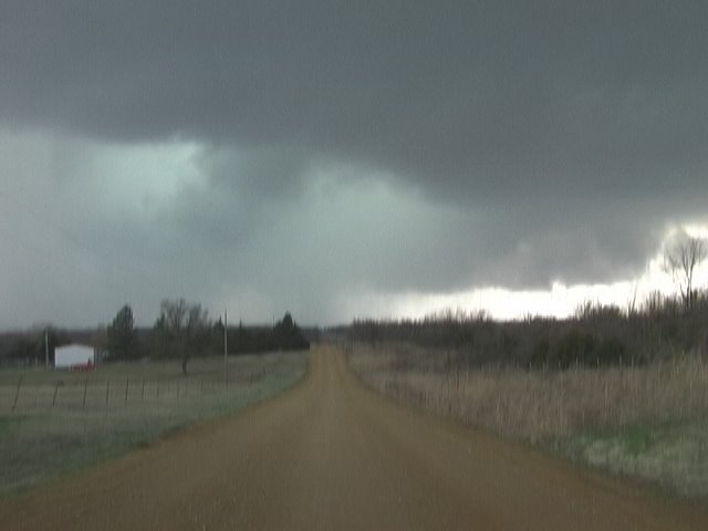
Ada supercell
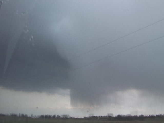
Well-defined hail shaft
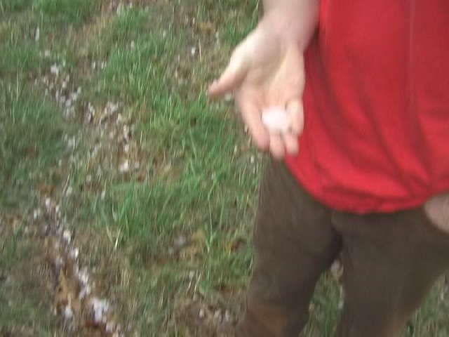
Brandon Lawson holds quarter to half-dollar sized hail.
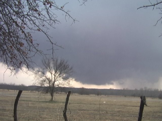
Very low wall cloud near Gerty, OK.
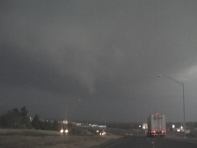
Brief funnel cloud NE of McAlester
# posted by Gabe Garfield @ 9:22 PM 
![]()